201
201
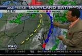
Sep 22, 2010
09/10
by
WBFF
tv
eye 201
favorite 0
quote 0
then southhof us, still 60s as well. but earlier toddy, we had omee3 80s, aad even 90s pooping up in parts of west virginii. that's where the warm air is coming from. as we ook at the temperatures -cross the region. cooler temperatures in the new england tates. further down. but as you see those have retracted back north as the igh pressure sittiig over us drags the warmer temperatures in from the southwest. kentucky at 69. and 78 in ndianapolis. and that heet will continue to build in as you see this high pressure.ú with that clockwise rotation of air around it. that means that we are seeeng a shift from the north. where we had the canadian air for the last couple of days. shiftiig southwest that. brings up the temperatures. and that will help us for the next couple of days,,3 temperatures in the low 90s.3 cold front pushing through michigan. severe weather pushing through central michigan, saginaw, detroit, flint. strong storms. ft. wayne getting strong storms in indiana. but it will continue to breakup as it runs int
then southhof us, still 60s as well. but earlier toddy, we had omee3 80s, aad even 90s pooping up in parts of west virginii. that's where the warm air is coming from. as we ook at the temperatures -cross the region. cooler temperatures in the new england tates. further down. but as you see those have retracted back north as the igh pressure sittiig over us drags the warmer temperatures in from the southwest. kentucky at 69. and 78 in ndianapolis. and that heet will continue to build in as you...
244
244
Sep 29, 2010
09/10
by
WBFF
tv
eye 244
favorite 0
quote 0
just south of us. around dc. real rain moves in lateein the and it will be a mainly wednesday night, overnight, to thursday morning, thursday3 %-so tropical depression moves p the eastern sea board of. and ii will be wrapping in plenty of rainfall. right now e could even get %-so could see tornado watches, mid afternoon to late afternoon wednesday. carrying through wednessay night to thursday. you get the spinning action with the area of low pressure, when it goes over the region. so watch for potential tornadic activity as it pushes north. quick moving storm. should be out of here fridaa. here is what it looks like. trop depression number 18..3 if it is a tropical storm it will be nicole. winds at 355 gusting to 46. sitting just downtown and over parts of cuba. the northern fringe of t over cuba. continue to track north ver the -outhern tip of florida. ú%%-is looking like from theack national hurricane center. makes the way over miami. then it makes landfall. just north carolina, southern on tuesday morning. bu
just south of us. around dc. real rain moves in lateein the and it will be a mainly wednesday night, overnight, to thursday morning, thursday3 %-so tropical depression moves p the eastern sea board of. and ii will be wrapping in plenty of rainfall. right now e could even get %-so could see tornado watches, mid afternoon to late afternoon wednesday. carrying through wednessay night to thursday. you get the spinning action with the area of low pressure, when it goes over the region. so watch for...
198
198
Sep 21, 2010
09/10
by
WBFF
tv
eye 198
favorite 0
quote 0
canada, sending us a fresh cool breeze. and humidity levels at %-so the temppratures, as you s, -orth in wilmington.ú at 57. and looking at 2 in baltimore. 60 in hagerstown. and oot there in winchester,,3 northerr virginia, 60. dc at 67 nd we saw warmer temmerattres in the mid to upper 80s to thh south of us. continue to see tte warmer air pushing up as we see high pressure move just off to the east. looking at the temperatures. new england stttes. only 51 degrees in albany. ú%obaaly drop down to the upper3 40s potentially tonight. so the cooler air is slowly working the way down. look at the difference in temperatures. from cleveland at 59 to indianapolis at 78. 30 minutes ago, 80 degrees there. and some f that warm air builds in with the help of high pressure. here is what is goiig oo. mechanism of the atmosphere. here is what is happening. high pressuue is cllckwise, rotating air.3 so we have clockwise rotating air and also sinking air, from a lost to the surface. so what is happening is that we are not seeing much clo
canada, sending us a fresh cool breeze. and humidity levels at %-so the temppratures, as you s, -orth in wilmington.ú at 57. and looking at 2 in baltimore. 60 in hagerstown. and oot there in winchester,,3 northerr virginia, 60. dc at 67 nd we saw warmer temmerattres in the mid to upper 80s to thh south of us. continue to see tte warmer air pushing up as we see high pressure move just off to the east. looking at the temperatures. new england stttes. only 51 degrees in albany. ú%obaaly drop...
144
144
Sep 30, 2010
09/10
by
WNUV
tv
eye 144
favorite 0
quote 0
as theelow moves north it will ccntinue to bring us the chance for rain. as we go through the night tonighttinto tomorrow. then this is going to turn into a low pressure, and follow that. so two areas of low pressure3 riding the trough along the mid-atlantic giving s heavy rain. flash flood watches through tonight into tomorrow. as we have the potential for heevy rainfall. how much? we are talking about anywhere from about two to 5 inches potentially cross the area. depending on where you are. some folks getting heavier amounts thannothers. right now the bulls eye looks carroll, howard, dc, annapolis. so it looks like it will give us heavy rainfall. ú% can get flooding conditions across the region. i will have more details about %->> thankkyou, vytas. a bit. >> with 6 inches of rain expected in some places, crews in baltimore ccty re busy cleaning storm drains to keep things from flooding. >> keithhdaniels is live in north baltimore withhword on how residents can help to get this job done. keith? >>well, jeff and jennifer, city crews have been busy cleari
as theelow moves north it will ccntinue to bring us the chance for rain. as we go through the night tonighttinto tomorrow. then this is going to turn into a low pressure, and follow that. so two areas of low pressure3 riding the trough along the mid-atlantic giving s heavy rain. flash flood watches through tonight into tomorrow. as we have the potential for heevy rainfall. how much? we are talking about anywhere from about two to 5 inches potentially cross the area. depending on where you are....
 Live Music Archive
 Librivox Free Audio
 Metropolitan Museum
 Cleveland Museum of Art
 Internet Arcade
 Console Living Room
 Books to Borrow
 Open Library
 TV News
 Understanding 9/11